Look What I Found!
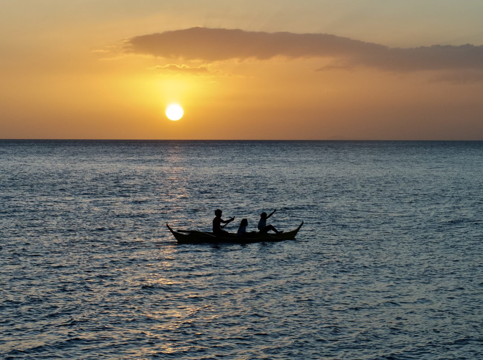
Every evening, just before sunset, Rhianna goes hunting.
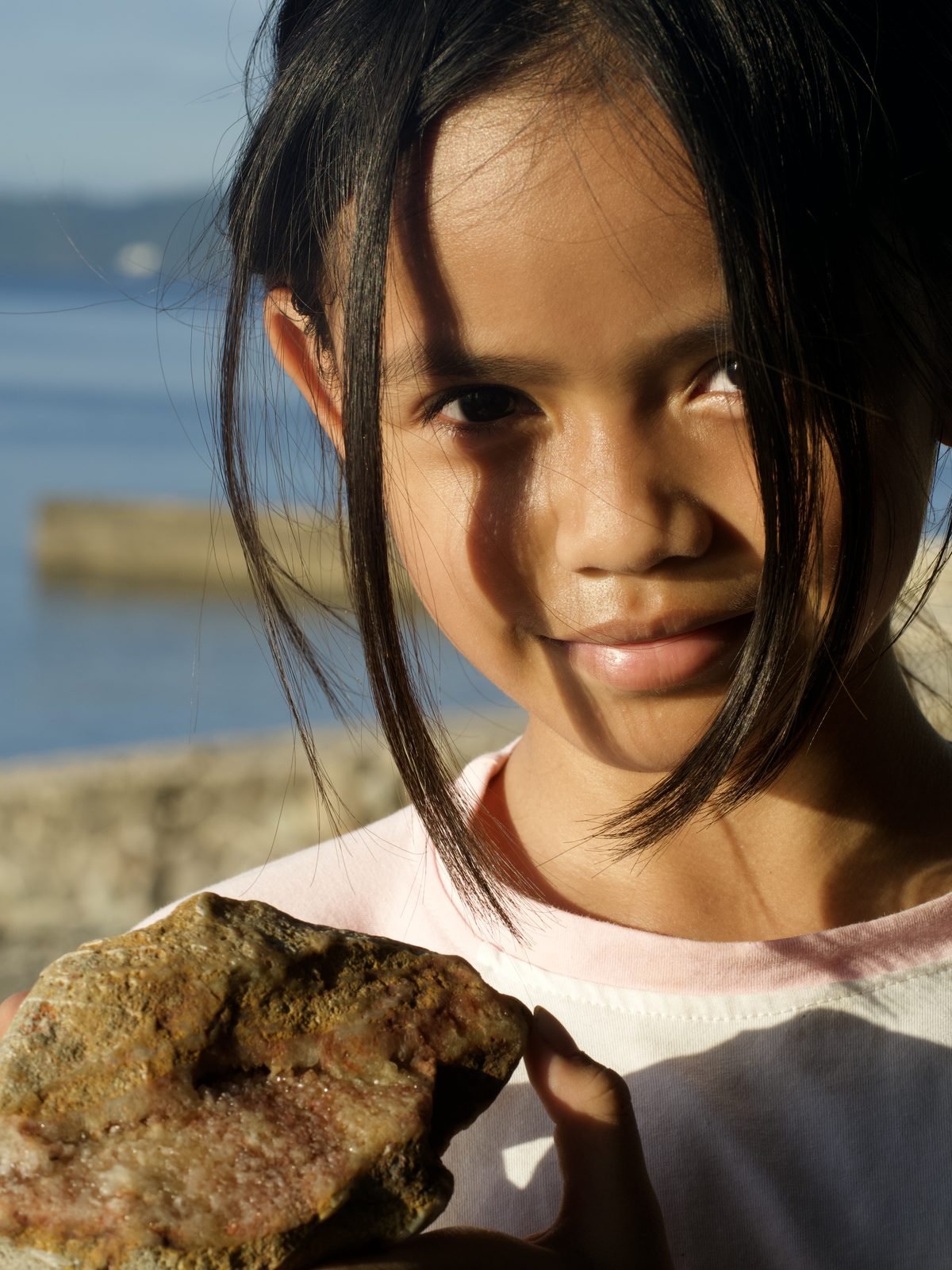
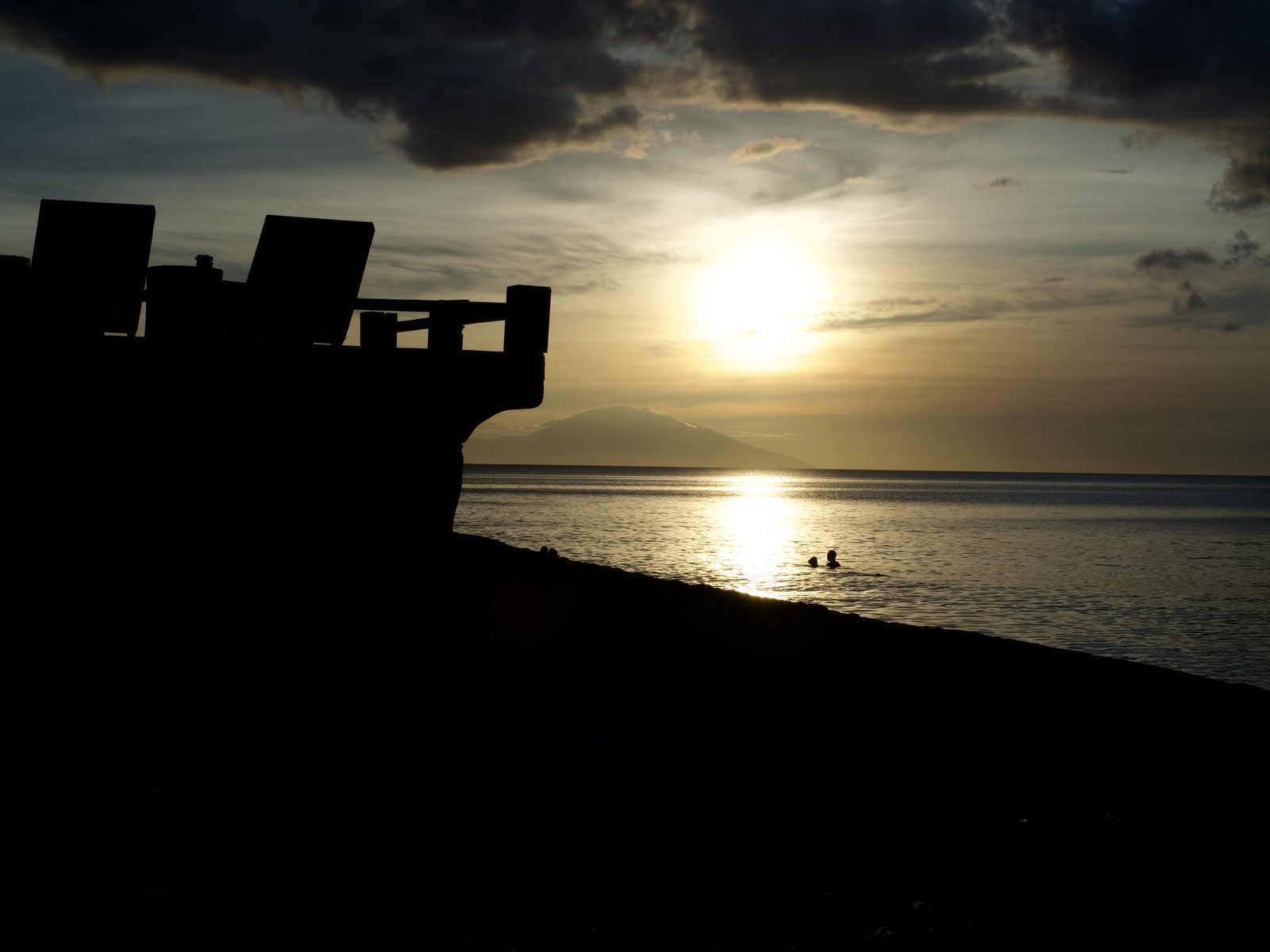
She’s nine years old, she’s barefoot, and she’s not looking for shells. She’s looking for treasure — real treasure, the kind that glitters. While the last light turns Balayan Bay to copper, she crouches on the dark volcanic sand in front of Blue Ribbon Divers and picks through the stones with the focus of a jeweller.
“Look! Gold!”
She holds up a flake of something that catches the light like metal. It isn’t gold. But what it actually is might be more interesting.
The beaches around Anilao are not ordinary beaches. The sand is dark — almost black in places — and mixed through it are fragments of crystal, glass, and minerals that don’t belong on a typical tropical shoreline. Rhianna’s collection, spread across a towel back at the resort, is a catalogue of geological violence: stones shot through with veins of crystal, chunks of rock with tiny cavities lined with glittering formations, dark glassy fragments that look like they were poured from a furnace.
They were. About fifteen kilometres from where she’s standing, across the water to the north, sits the reason all of this is here.
Messages from the Deep
The gold that Rhianna finds is biotite mica — a mineral that forms deep inside volcanic systems and weathers out of ash deposits over thousands of years. Each flake is a tiny mirror of silicate crystal, and in the right light it genuinely looks like flecks of gold scattered across the sand. The beaches around Batangas are full of it.
But mica is just the beginning.
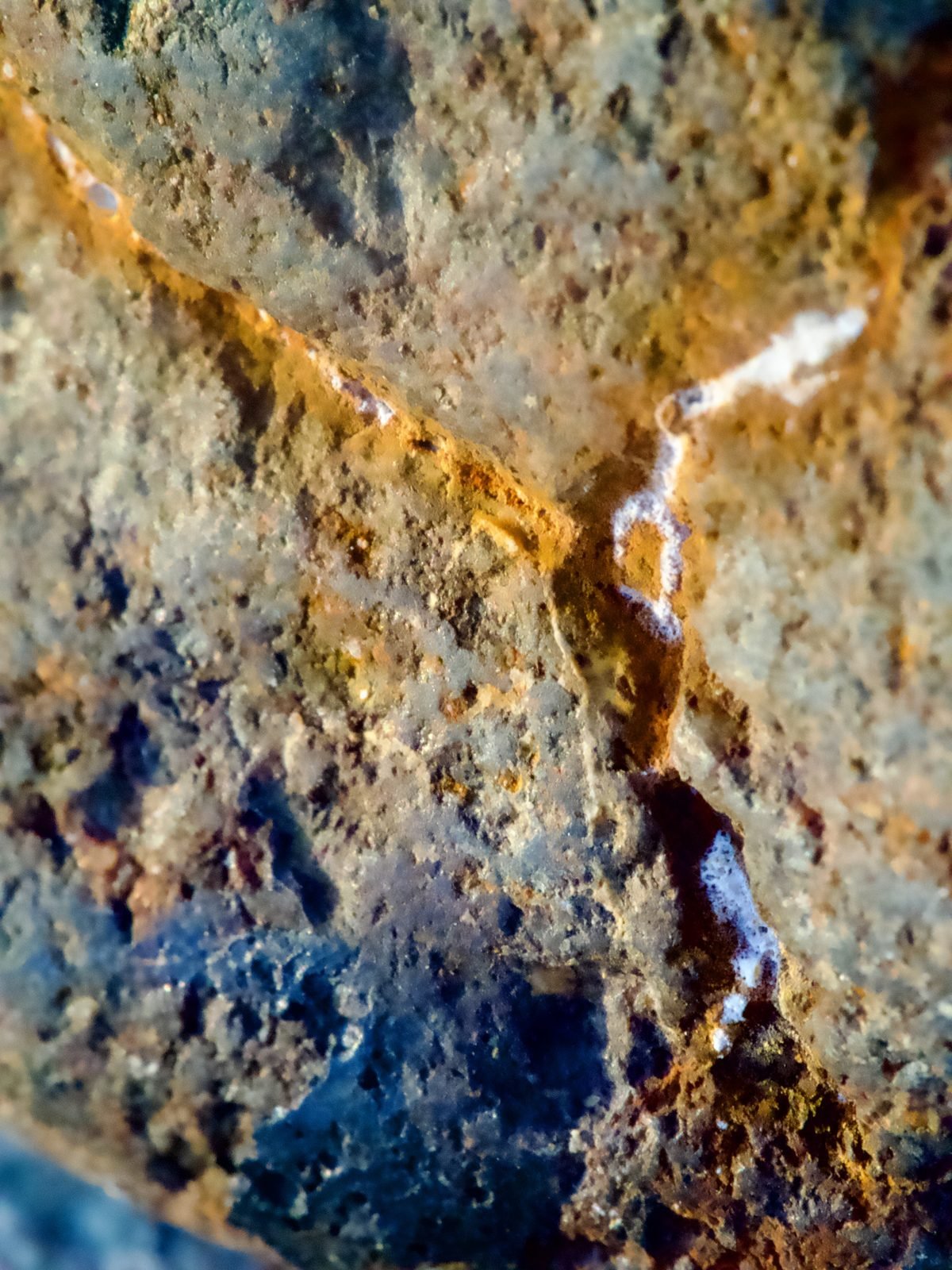
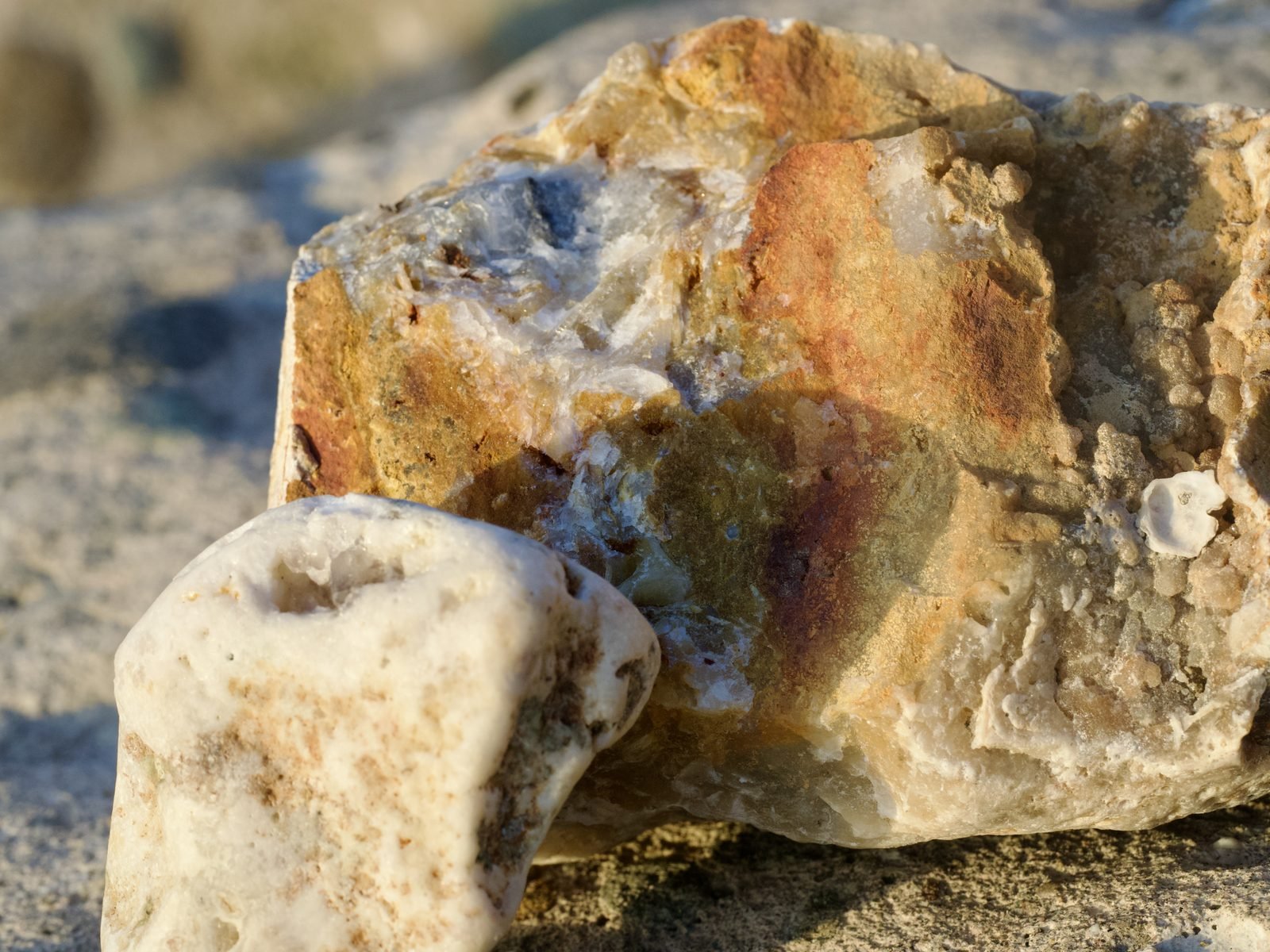
Among Rhianna’s collection are pieces of chalcedony — a translucent, waxy form of quartz that forms when silica-rich fluids fill cavities in volcanic rock. The specimen she found most recently is a chunk of dark volcanic host rock with small vugs (cavities) lined with druzy crystals, the classic signature of hydrothermal activity. Water superheated by magma, carrying dissolved minerals, forced its way through cracks in the rock and left crystals behind as it cooled. The stone in her hand is a message from kilometres below the Earth’s surface, delivered over geological time.
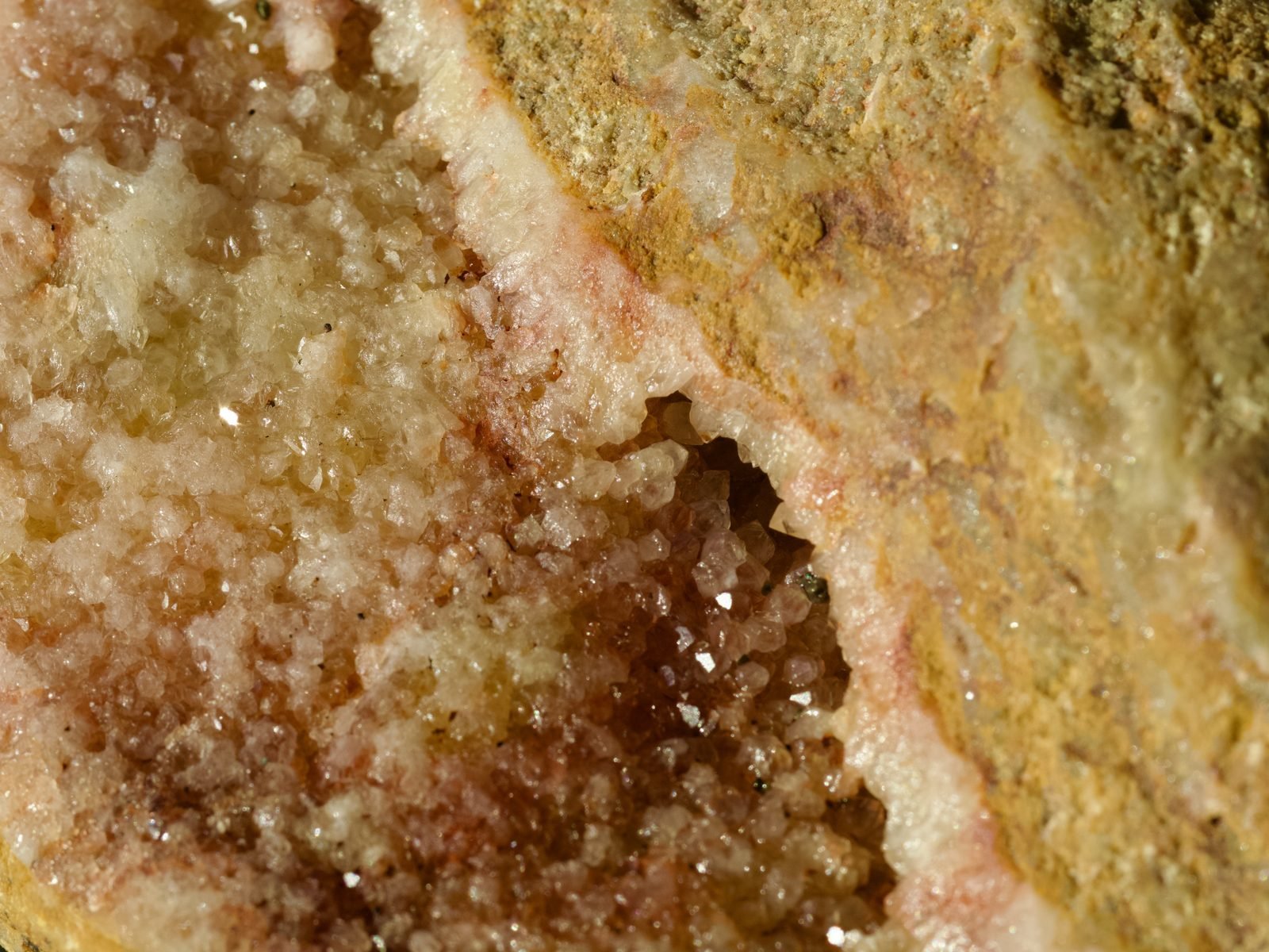
The colours hint at what’s inside. Iron oxides paint stones rust-red and orange. Copper minerals leave traces of blue-green. Manganese produces purples. Clear or milky white usually means quartz. And the heavy black grains you can pull from the sand with a magnet? That’s magnetite — the same mineral that gives basalt its magnetic properties, and it’s everywhere on these beaches.
Then there’s the volcanic glass — dark, smooth fragments of basaltic material that cooled so quickly it never had time to form crystals. And scattered among it all, small green grains of olivine, the mineral that gemologists know as peridot, eroded from ancient lava flows.
Every one of these minerals tells the same story. They all came from the same place.
The Mountain That Vanished
Fifteen kilometres north of Anilao, across a stretch of water that doesn’t look like much, there’s a lake. In the lake there’s an island. On the island there’s a crater. In the crater there’s another lake. And in that lake there’s another island.
This is Taal — and the reason it has this impossible Russian-doll geography is that it used to be one of the largest volcanoes in the Philippines.
The original Taal was a stratovolcano that stood somewhere between five and six thousand metres tall. To put that in perspective: Mount Fuji is 3,776 metres. Kilimanjaro is 5,895. Pre-historic Taal was in that range — a massive, snow-capped peak visible for hundreds of kilometres, towering over what is now the Batangas coast.
It’s gone now. What remains is a 311-metre stub called Volcano Island, sitting in the middle of a lake that fills the caldera the old mountain left behind. The caldera is 25 to 30 kilometres across. You can see it on Google Earth — that vast, almost perfectly circular body of water is the footprint of something enormous that used to be there and isn’t anymore.
Four times, Taal tore itself apart.
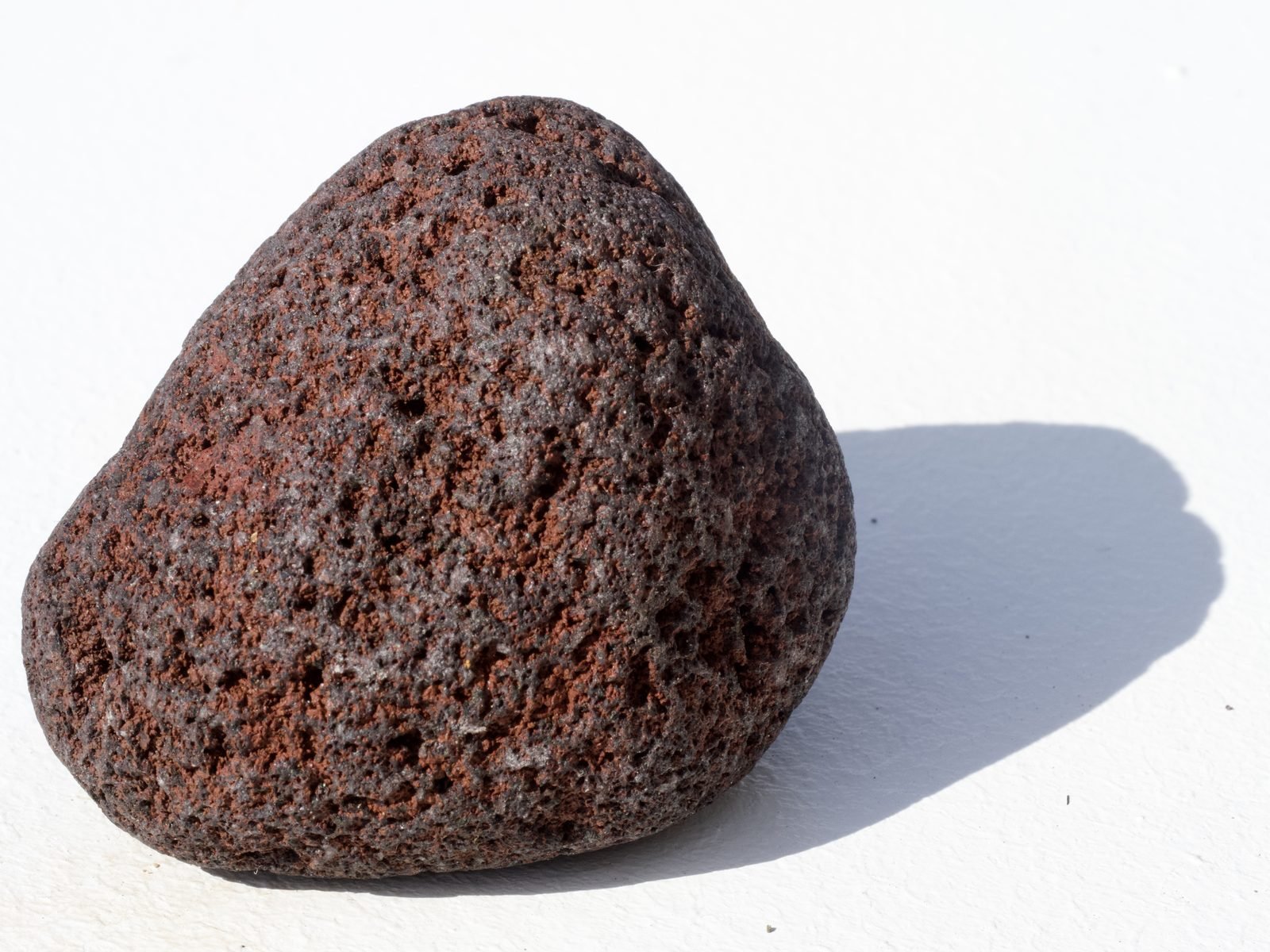
The largest of those eruptions — the Pasong Formation event — ejected 144 cubic kilometres of material. That’s approaching VEI 7, the same scale as the eruption that created Crater Lake in Oregon or the Minoan eruption that destroyed Santorini and may have ended the Bronze Age. The most recent caldera-forming event, about 5,400 years ago, deposited 50 cubic kilometres of scoria across the region. That scoria — dark, bubbly, vesicular rock — still litters the beaches and hillsides of Batangas today.
This is what Rhianna is finding. Her crystals, her gold, her strange glassy stones — they are fragments of a mountain that no longer exists, scattered across the landscape by eruptions that reshaped the geography of southern Luzon.
Swimming Through Fire
If the crystals on the beach are messages from Taal’s past, then just offshore from Anilao there’s a place where you can visit the volcano’s present.
The dive site known locally as Bubbles — and formally documented by scientists as Soda Springs — sits at a depth of about ten metres in Secret Bay, Mabini. Here, the seafloor vents gas. Streams of bubbles rise from cracks in the rock, and the water shimmers with heat distortion. It looks like someone left a pot boiling on the ocean floor.
In 2020, a Filipino-led research team under Dr. Bayani Cardenas from the University of Texas at Austin measured what was actually coming out of those vents. The carbon dioxide concentration was 95,000 parts per million — more than two hundred times the atmospheric level. The water temperature at the vents reached 60 degrees Celsius. The pH dropped to 5.4 — acidic enough to dissolve shell.
These are the highest CO2 concentrations ever recorded at any submarine vent system on Earth. The study, published in Geophysical Research Letters, confirmed what local divers had long suspected: the bubbles at Bubbles are volcanic. Magmatic CO2 from Taal’s subsurface plumbing system — the same hydrothermal reservoir that was mapped by geophysical surveys beneath Volcano Island, a 3 by 3 by 3 kilometre cube of superheated fluid at 2.5 kilometres depth — percolates laterally through fractures in the surrounding rock and discharges on the seafloor of Balayan Bay.
When Taal’s activity increases, the springs produce more bubbles.
What makes this remarkable isn’t just the chemistry. It’s what lives there. Corals and marine organisms thrive surprisingly close to the vents, adapted to conditions that would seem hostile to life. The site is popular for muck diving — the sandy bottom and volcanic micro-environment attract rare and exotic species that you won’t find on a typical reef. Life doesn’t just tolerate the volcano. It adapts to it. It uses it.
You can dive Bubbles on a day trip from Blue Ribbon. You’ll swim through dissolved volcanic gas from the same magma system that built the crystals on the beach.
A Lake That Was Once a Sea
The story of Taal gets stranger the deeper you go.
Before 1754, Taal Lake wasn’t a lake at all. It was an inlet of Balayan Bay — a body of saltwater connected to the sea through the Pansipit River, which was wide and deep enough for sailing ships and Chinese junks to pass through freely. Spanish colonial records describe a navigable waterway linking the ocean to what was then a marine bay surrounded by thriving towns.
Then, on the 15th of May 1754, Taal erupted. It didn’t stop for seven months.
The eruption — classified VEI 5, the largest in Taal’s recorded history — produced base surges that crossed the lake at 80 kilometres per hour, buried four major towns under ash and rock, and forced the relocation of the provincial capital. But its most lasting impact was geological: the eruption blocked the Pansipit River with tephra, severing the lake’s connection to the sea.
The water level rose. Monsoon rains diluted the salt. Over decades, then centuries, the marine bay became a freshwater lake — and the creatures trapped inside it became some of the most extraordinary evolutionary stories in the Philippines.
The tawilis — Sardinella tawilis — is the world’s only freshwater sardine. Found nowhere else on Earth, it is believed to be the descendant of marine sardines trapped when the 1754 eruption sealed the bay. It is now listed as Endangered on the IUCN Red List.
The Lake Taal sea snake — Hydrophis semperi — is one of only two sea snake species on the planet that lives almost exclusively in freshwater. It adapted to its landlocked environment after the volcanic events of the 16th and 17th centuries isolated the lake. It is found nowhere else.
And until the mid-twentieth century, bull sharks patrolled the lake — marine predators that had entered through the Pansipit when it was still a sea channel, exploiting their rare ability to tolerate freshwater. They were hunted to extinction by local fishermen by the 1930s.
A volcanic eruption turned a sea into a lake and created species that exist nowhere else on the planet. The tawilis, the sea snake, the lost bull sharks — they are all consequences of the same geological engine that scattered crystals across Rhianna’s beach.
The Treasure Beneath
There’s a reason the Philippines is like this. There’s a reason the beaches are made of volcanic glass and crystal, the seafloor vents gas, mountains vanish into calderas, and the waters hold more species of marine life than anywhere else on Earth.
The reason is underneath.
The Philippines sits on one of the most tectonically active boundaries on the planet — the convergence of three tectonic plates. To the west, the Manila Trench marks where the South China Sea Plate is being driven beneath the Philippine Mobile Belt. To the east, the Philippine Trench does the same from the other side. The archipelago is being squeezed between two subduction zones, and the result is a chain of volcanoes, a wealth of minerals, and an ocean environment of staggering biological richness.
The Manila Trench drops to over 5,400 metres — a chasm in the seafloor that runs south past Lubang Island and channels deep, nutrient-rich water upward through the Verde Island Passage, the strait between Luzon and Mindoro that scientists have identified as the “centre of the centre” of marine shorefish biodiversity. This is why Anilao has over 600 species of nudibranch. This is why the Philippines has been named the World’s Leading Dive Destination for seven consecutive years. The deep trench is a conveyor belt of nutrients, feeding the richest marine ecosystem on Earth from below.
Taal sits directly on this western volcanic arc. The crystals on the beach, the CO2 vents at Soda Springs, the rare earth minerals being surveyed on the Philippine Rise 250 kilometres to the east — they are all products of the same subduction engine. The same geological forces that create devastating eruptions also create mineral wealth that is almost beyond comprehension: the Philippines holds an estimated one trillion US dollars in untapped mineral reserves, with only five percent of the country explored.
And it doesn’t stop at geology. The ancient maritime trade routes that passed through these waters carried jade from Taiwan to workshops in Batangas as far back as 1,500 BC — nephrite jade artefacts have been found at archaeological sites across the province. Long before the Spanish arrived, the Philippines was a hub of a vast Pacific trading network, and the minerals beneath these islands were part of the reason why.
The same forces that built the mountain, scattered the crystals, vented the gas, trapped the sardines, carved the trench, and fed the reef — they also drew human civilisation here, thousands of years before anyone called it the Philippines.
Back to the Beach
The sun is setting over Balayan Bay. The light has gone from gold to amber to the deep red that only happens in the tropics, where volcanic dust in the atmosphere — even now, even at Alert Level 1 — scatters the wavelengths just so.
Rhianna doesn’t know about subduction zones or VEI ratings. She doesn’t know that the flake of gold in her hand is biotite mica that formed kilometres below the surface of a mountain that no longer exists. She doesn’t know that the strange, glassy stone with crystals inside it was made by superheated water forced through volcanic rock by the same magma system that feeds the bubbling vents just offshore.
She knows it’s beautiful. She knows it glitters. And she knows there’s more of it if she keeps looking.
That might be the most honest way to experience the Philippines. Not through statistics or strategy documents or tourism campaigns, but through the simple act of picking up a stone on a beach and wondering where it came from. The answer, it turns out, goes deeper than you’d ever expect — through volcanic history, through evolutionary biology, through the deep structure of the Earth itself, through four and a half thousand years of human trade, through the mantle of the planet and back up again to the surface, where a nine-year-old holds it up to the light and says:
“Look what I found.”
Rhianna’s crystal collection is growing. If you’d like to see her latest finds — or if you’ve picked up something interesting on the beaches around Anilao and want to know what it is — follow us on [social media link] or drop by Blue Ribbon Divers and ask. We’ll do our best to identify it.
Blue Ribbon Divers is an SDI/TDI 5-Star Dive Centre in Anilao, Mabini, Batangas — the birthplace of Philippine diving, in the heart of the Verde Island Passage.